Sunday 30 October 2016

Why Water Resources Assessment? (2) For Money!

Following on from the previous post, I will now address the second major reason for the implementation of WRA.

The continent Africa has tremendous growth potential based on its resource availability with water being one central component. To support a sustainable socio-economic development in Africa, it is absolutely necessary to have a critical understanding of the hydrological system in this vast geographical area that has extremely variable meteorological and geographical conditions. It goes without saying that accurate information on the condition and trend of a country’s water resources is a prerequisite to a better future in Africa, especially when the population growth and climate changes put increasingly pressure on the already scarce water resources.

According to the United Nations Economic Commission for Africa, water has an economic value in itself. It states that there needs to be a wider appreciation of water in this respect to prevent ‘wasteful and environmentally damaging uses of the resources’. To achieve this, it offers WRA as a way of best evaluating the economic value of water.

As with all government spending and programme, water resources assessments need to be justified, whether environmentally, socially or economically. Under the current homogeny of neoliberal capitalists society, every penny spent logically should be backed up with some cost and benefit analysis. In addition to the economic benefit of water itself, researchers have also found that the benefit-to-cost ratios for hydrological data collection alone ranges from 5 to 10 (i.e. for every pound you invest in hydrological data collection, you make 5-10 pounds out of it in the future), with some even going up to 40. WRA therefore play an important role in guiding water resources management.

Another great example that supports the use of WRA in IWRM is the simulation of river discharge at the Hadejia-Nguru Wetlands. Through modelling different scenarios of dam operation and construction, it is shown that the less implementation of dams and irrigation scheme, the greater the flood extent and the less reduce in groundwater storage. the authors suggest that for a more sustainable water resources management, it is best to regulate river discharge according to its natural environmental regime that harmonises with the social-economic activities and biodiversity of the region.

This view is echoed in Barbier’s (2003) finding that ‘there is a direct trade-off between increasing irrigation upstream and impacts on the floodplain downstream’. Through putting economic values on the ecosystem services the river provides, it suggests that a full implementation and construction plan of dam operation would result in a loss of US$20.2 to 20.9 million. However, if mitigation plan were put in place, it would help save US$4 million worth of money. According to Save the Children, you could make lasting changes to African children’s living conditions with less than $1 a day. Assuming that to support a child into his adulthood (say, 20-year-old), it would take about $7300. With the $4 million saved, we could help an extra 547 children in Africa!

WRA is not just limited for use by the government. It is also tremendeously useful for the private sectors (e.g. engineering and construction companies) as it provides critical information for planning, development and operation processes. For example, the company ARCADIS produced a comprehensive assessment on water sustainability for major cities around the world and rank them against each other. The report looked at aspects such as water resilience, efficiency, and quality and the city, Rotterdam, came out on top out of 50 cities evaluated. It suggests although the city itself lies below the sea level, due to its excellent water management and robust flood defences, it scores one of the highest in terms of its water resilience. Information provided by this WRA helps to attract more investment as it allows a much more accessible communication to stakeholders and potential clients. It shows that WRA is not just limited to government but also very useful to the private sector.


Overall, these example show why we should pay much more attention to WRA, at least from an economic standpoint. 

Saturday 29 October 2016

Why Water Resources Assessment? (1) For better management

As the only person in the year studying the topic of water resources assessment (WRA), I feel I have the responsibility to convince everyone why this topic is so vital, if not, probably the most fundamental aspect of all hydrological studies and management. Personally, I think there are three reasons for this:
  • The rise of integrated water resource management (IWRM)
  • Economic benefits of WRA
  • Variability of water resources (particularly in Africa)

In this post, I will address the first reason.

The concept of managing water resources in an integrated manner has always been observed. For example, in the 20th century, Spain already pioneered in managing its water resources based on the delineation of watershed. It also allowed multiple stakeholders to participate in its management. Since then, similar actions have also been taken in countries such as the USA and Germany.

Although relatively absent from the political agenda until the 1990s, the idea of sustainable exploitation and management of water resources became increasingly popular later on in the world due to the collective effort of several international organisation and conferences. For example, the Second World Water Forum and Ministerial Conference addressed the issue of water resources inequality by including more than 5700 participants (including all kinds of stakeholders, not just ‘experts’) in its discussion of water resources management. The World Summit on Sustainable Development held in Johannesburg, South Africa in 2002 advocated for all nations to develop IWRM and become more water efficient.

IWRM have evolved from its earlier stage where there was limited cooperation between different sectors in the 1950s to the management-oriented phase in the 1980s and now the goal-oriented phase. The current phase recognises the importance of interactions between various aspects (e.g. social, economic, groundwater, geology, hydrology etc. See Fig1&2) and requires the goal of the IWRM plan to be laid out clearly at the start of the planning process. Water resources must be managed in ways that meet the needs of present and future population as well as the expectations of many different sectors through a consensus-based approach.

Figure1. An integrative approach to water resource and watershed management.


Figure2. A visual representation of IWRM.

Since so many people are involved in such a process, it is vital that it is done fairly and uses legitimate, reliable, and accurate data. This is where water resources assessment come in. Through coordinating data and information from different sectors (e.g. agriculture, forestry, water supply, and environment), regions or even countries, it avoids conflicting information being produced. According to the technical material for water resources assessment, without proper water resources assessment, it could ‘undermine the importance of credibility of the work of the National Hydrological Services.’ Water resources assessments ensure that the information and analysis produced are robust and can be trusted by various stakeholders with potentially conflicting motives. That way the recommendations made by the water resources managers are more likely to be enforced smoothly.

Further, with good quality analysis, we may then have a good understanding of the complexity of hydrological system and how much water can realistically be allocated to different sectors and stakeholders. This fundamental idea is reinforced particularly by conferences such as the World Water Forum throughout the last 30 years.


In short, due to the rise of IWRM and its associated attempt to manage water resources in a more fair, sustainable and efficient manner, water resources assessment become a must.

Tuesday 25 October 2016

History of Water Resource Assessment in South Africa

This blog post will focus on the history of water resource assessment.

For the peers in Geog 3057 and anyone out there who happened to stumble upon my blog, you might be wondering, ‘What has the history of water resource assessment got to do with this module? I am here to take a geography module, not a history module!’ Well, I’ll tell you why. The short answer is: For all the analyses that we are able to carry out today, they are all built on the ones in the past. As Pitman rightly wrote in his article, ‘Where we stand todayis a consequence of what has been done before – a prime example of the ‘weightof history’’.

We improve our assessment by learning from our mistakes and insufficiencies in the past and hopefully progress forwards. There are many techniques that would not have been available had the power of computer and methods of calculations not been advanced. They allow the development of hydrological models from the simple black box models to sophisticated and data intensive spatially-distributed models. Of course, some basic techniques are still well and alive today, e.g. mean annual discharge and rainfall and flow regime. They have all been instrumental in the understanding of hydrologic system and the paradigm shift of water resource management (shift from large scale dam to more integrated water resource management).
The methods used to assess the water resources in South Africa from the 1950s onwards have seen significant progress, nonetheless faced with new challenges as well. In the 1952 study done by Midgley, there were no such things as computers! For a millennial like me who has been blessed with the invention of laptops and their applications, it seems insane to carry out all the calculations manually. Later, in 1969, Midgley and Pitman were able to advantage of the main-frame computer at the time as an aid for calculations, although its power is nowhere near to what we have today. Luckily, in the 1994 study by Midgley et al, PC and (Geographic Information System) GIS were available. They allowed the researchers to add in components of land use change and better redefine catchment boundaries. This was fundamental as in the past, the hydrological records in catchment area that had undergone significant land use change would simply be rejected for use in models. This means that the models are able to simulate the actual historical changes on land, allowing a much better calibration in models. Processes such as urbanisation, afforestation, irrigation and abstractions as well as the presence of reservoirs can finally be considered. Additionally, the resolution of maps has improved from 1:50 000 in 1981 to 1:1 000 000 in 1994. We therefore see a major improvement in the ability of hydrological models in less than 50-year time.

It is not just the power of the model that has improved, hydrological theories have also advanced during this period. In the 1969 study, Midgley and Pitman introduced the concept of risk when calculating the relationships between reservoir storage and yield. Mean annual runoff and precipitation were compared for all gauged catchments so zones with similar rainfall-runoff relationships were recognized. In 1981, Midgley et al through using a deterministic rainfall-runoff model were able to extend the flow records given there were available and suitable rainfall data. This increases the volume of data up to 334 flow records, considerably greater than previous studies done in South Africa. In the 1994 study, Midgley et al recognised the importance of land use change and were able to investigate their effects on the hydrological systems.  In Middleton and Bailey (2008), the experience of many practising hydrologists was compiled and they suggested greater attention needs to be paid to the interaction between surface water and groundwater in models. Also, they recognised issues such as deteriorating water quality and runoff reduction caused by afforestation and non-native vegetation. Many more aspects of hydrology have therefore been taken into account in contemporary water resource assessments compared to those in the 1950s.

Despite the advances made in both technology and theories, the quest for better understanding of hydrology has been fought with several challenges in South Africa.

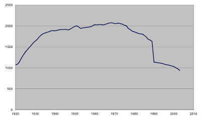
There has been considerable decline in the number of both rain and river gauging stations (see Figure 1 and 2). The number of flow gauge peaked in 1980s and dropped by 100 in less than 20-years-time whereas the number of rainfall stations have returned to the level in 1920s. This is largely due to a reduction in funding for water resource agency such as South African Weather Services (SAWs) and Department of Water Affairs (DWA) and lack of training in education system (Herold 2010). This presents a huge problem for the researchers if the trends are to continue. As Pitmann (2011) has stated, ‘all of the computing power in the world is useless without the appropriate data to be processed.’ This is especially true when the scientists are trying to discern the impact of climate change on hydrological systems. Without good quality data, it becomes even harder to make predictions and prepare for extreme natural events in the future.

Figure1. Number of rain gauges.
Figure2. Number of river gauges.


Processes such as land use changes, population growth, urbanisation, infrastructure leakage and pollution also present challenges to water resource assessment. All put greater pressure on the available water resource. Hydro-ecologist also recognised the role of natural flow regime for the maintenance of ecosystem services. This calls for a much more comprehensive assessment of water resources, not just simply looking at the volume of water. To able to do so, we absolutely must encourage the government to invest more in the hydrological monitoring network and personnel!

Sunday 23 October 2016

Introduction to water resources assessment (WRA)

Definition of water resources assessment

According to the World Meteorological Organisation (WMO), its definition is 


'the determination of the sources, extent, dependability and quality of water resources for their utilization and control, and water resources are the water available, or capable of being made available, for use in sufficient quantity and quality at a location and over a period of time appropriate for an identifiable demand.'


General approach

To assess, according to the oxford dictionary, means to evaluate or estimate the nature, ability, or quality of something. For one to complete water resources assessments, the various ways in which the water resources are affected (through changes in inflow/outflow/storage and their interrelationship) and its nature (i.e. variability) must be studied and understood. The figure below shows how a hydrological system is normally conceptualised.


Figure1. A simple conceptualisation of hydrological system.

A comprehensive WRA will allow the hydrologists to estimate the volume of sustainable surplus flow, which could then inform the decision makers on related development and water management e.g. the construction of dams, although this is not always the case. It is particularly important nowadays given the uncertainty and risks surrounding the issue of climate change and biodiversity loss as well as the impact of population growth and rapid urbanisation in Africa, all of which wield significant influence on the hydrological system itself (). In line with the 2015 sustainable development goals, the WRA should guide water resource management (WRM) in ways that will allow both the present and future population enjoy clean and adequate water supplies to meet their social, economic and environmental needs. 


Scales of water resources assessment

All water resources assessments need to have a clear hydrological boundary. Without it, data collection cannot be done. ideally, one should consider all the following factors in drawing up the boundary 

  • River watersheds
  • Groundwater systems
  • Administrative divisions
  • Transnational boundaries
and the characteristics of the surface water and groundwater flows.


What are the steps then?

See Fig2 for a work-flow diagram.
  1. Define boundaries of assessment
  2. High level review to determine dominant behavior and processes
    • Which processes are significant in this catchment e.g. In Taiwan, due to its steep relief of river channels, surface flow is vital in model representation.
  3. Data collection
    • Hydrometerological and hydrogeological: climate (rainfall, temperature, moisture level), surface water flow, groundwater level 
    • Biophysical: topography, vegetation, geology and soil
    • Socio-economic: land use, demography, 
    • Water use: water consumption by adminstrative region
  4. Data analysis
  5. Modelling the changes in catchment behaviour
    • e.g. Thompson et al (2013)'s modelling results showed that the risk of ecological impact from changes in discharge increases in River Mekong, especially for low-flow seasons. 
  6. Assess sustainable and exploitable water over evaluation period
    • e.g. Thompson et al (1995) through incorporating various different operating scenarios of dams demonstrated that further construction of dam could lead dramatic reduction in water downstream, affecting the income and livelihood of those relying on agricultural productivity. 
  7. Presentation of water resources assessment
Figure2. Workflow of WRA.


Hope you enjoyed reading this post, next week I will be blogging about the history of WRA in South Africa.

Wednesday 19 October 2016

Welcome!

Hello Everyone! The time has finally come for me, as a humble third year geography student at UCL, to make some impact in the world. The topic at hand will be focusing on the water and related crisis in Africa, and more specifically, the role of water resources assessment in the management of water resources and resultant consequences on other aspects of livelihood of people in Africa.

Now that must have sounded like quite a mouthful! To clarify, water resources assessment and management are two different yet inextricably linked matter. To effectively manage the water resources available, one must study and understand the system through various ways of assessments.  The assessments may be either qualitative or quantitative. These may include narrative descriptions of the extent and severity of flood and climatic projections of river discharge, flood or drought. Both complements each other and are vital in enabling a comprehensive understanding of water crisis. The information gathered can be turned into useful knowledge that can inform policy makers. However, this linear model of knowledge production does not always happen. Things get messy in the real world!

In this blog, I will aim to achieve the following:

  • explain what water resources management is and its relationship to integrated water resources management
  • address the need to have greater number of water resources assessment in Africa. 
  • discuss the role of citizen science in water resources assessment
  • disentangle the complex relationship between water resources assessment and management and seek to discuss why water resource managements sometimes could not go accordingly to the goals. 

The continual advancement in technologies e.g. remote sensing and better models, and hydrological theories mean the assessment will also be changed and improved continually.  This is and always will be intertwined with the ever-changing landscape of human geography in which different stakeholders with different attitudes and motives interact, compete and even compromise eventually. As with climate science, the ‘science’ itself is often contested and challenged by various stakeholder in various ways with different motives. It is my ultimate goal to unpack their messy interrelationship and hopefully this will contribute towards the contemporary challenges of water crisis in Africa.